


Weather4D and Digital Yacht
Digital Yacht NMEA to Wireless devices and wireless AIS products are the ideal partner for Weather 4D – a powerful navigation, charting, instrument, routing and weather app for iOS. You can see some of the capabilities HERE
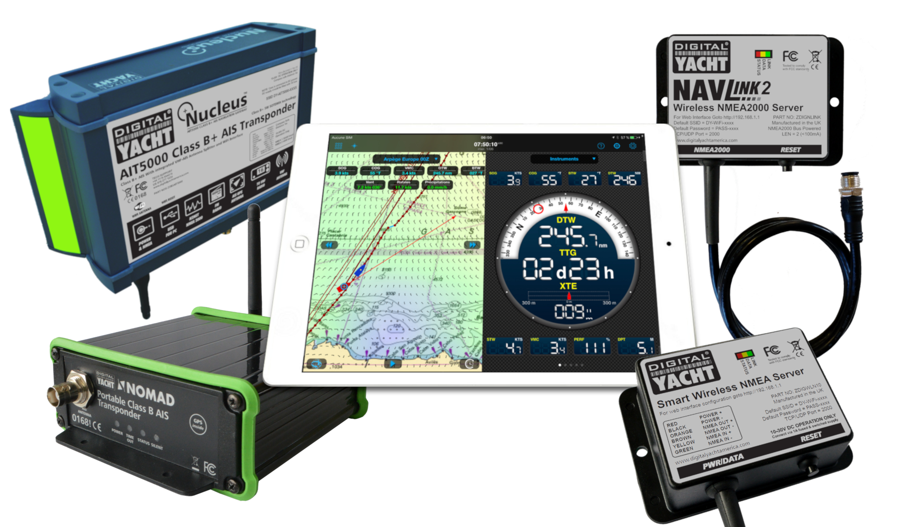
We’re pleased to be able to offer a 1 year FREE subscription to the weather service of the Weather4D app with the purchase of any Digital Yacht wireless product such as the WLN10, WLN30, NavLink 2, AIT3000, AIT5000 or Nomad. To take advantage of the offer, simply follow the details below:
Conditions of the offer
Visit https://www.weather4d.com/en/special-offer and provide your name and email address. Please also upload:
- A copy of the invoice for the Digital Yacht product
- A copy of the invoice from Weather4D Routing & Navigation issued by the App Store
You must have purchased the app and the qualifying Digital Yacht product within a maximum period of 15 days between the two purchases.
The offer is valid if the purchase of a Digital Yacht product has been made directly, in a store, via a distribution network or by a marine electronics installer.
This offer will run until 31/12/2019
The app Weather4D Routing & Navigation
Weather4D Routing & Navigation is an application that integrates weather and oceanographic forecasts, routing calculations and detailed maritime charts on your iPad and iPhone.
It’s a comprehensive app solution based on accurate meteorological and oceanic data downloadable in GRIB format, a wide range of nautical charts published by the official hydrographic services of 17 countries and real time data from your boat’s NMEA system via a Digital Yacht gateway.
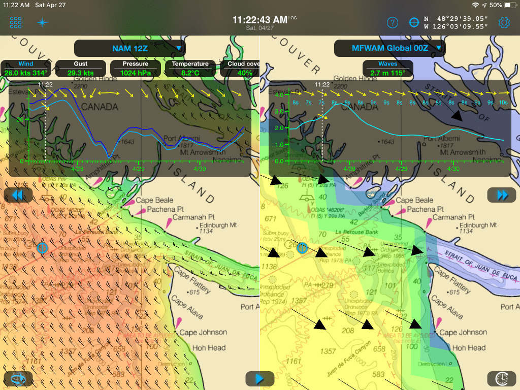
Weather forecast
Discover more than 35 weather and oceanographic weather prediction models with a one year subscription for FREE when you purchase the Weather4D Routing & Navigation application combined with one of Digital Yacht’s wireless NMEA/AIS products.
Routing
Create a route and calculate the associated routing based on departure dates and times, forecasts (weather, waves and currents), minimum sailing speed, motor speed, polars, maximum wind and minimum distance to the coast. It makes long distance passage making safer and quicker – optimising the route for your boat and current conditions.
Create waypoints, locations, simulate routes, combine them with GRIB forecast models and get an overview of all parameters that influence routing calculations.
Restart the routing calculation from the boat’s position at any time.
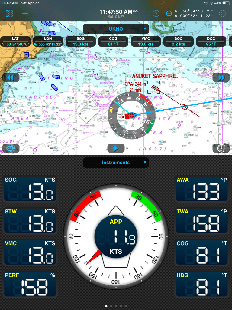
Display SOG, COG, VMC, HDG, TWS, AWS, ETA, AIS, etc in real time, as well as weather and routing.
Navigation
Download the latest charts from the comprehensive gloabal GeoGarage database for offline or offshore navigation. Choose charts from leading suppliers such as UKHO, SHOM, NOAA etc – detailed, government quality charting
Set the screen to night mode to better see what’s happening outdoors during your shift.
Activate alarms for AIS collision alerts, XTE, deviation off course, strong winds and shallow water.
Optionally share your boat’s AIS, wind, current, pressure, air and sea temperature with other Weather4D users
MOB alarm with sophisticated back-track calculations
All these navigation functions become possible by connecting the application to one of our NMEA WiFi servers or to one of our AIS transponders with integrated WiFi.
Comments 1
Comments are closed.