


Utilising a PC on board brings important benefits not just for regular PC tasks such as email and web access but also for entertainment and navigation. This document explains how to integrate a PC into a boat’s navigation system and this approach offers substantial cost savings over buying a multi station traditional navigation suite. PCs also provide a much more powerful platform and with an internet connection, data such as weather can be integrated into the system. Navigation software for a PC is sophisticated yet easy to use.
Installed PC or notebook…
Whilst a laptop or notebook provides a solution to run e-navigation software, it’s not ideal. Power consumption is high and often you will need an inverter or adaptor to connect to the boat’s DC supply which introduces more losses and electrical noise. Notebooks don’t like the constant vibration and momentum from the boat and of course they’re not designed for salty air. They also don’t have interfaces for the boat’s NMEA system so integration can be tricky. We’ve found that most users trial a system with a notebook but move on quickly to a dedicated, installed system like our Aqua range of PCs.
Aqua PCs from Digital Yacht
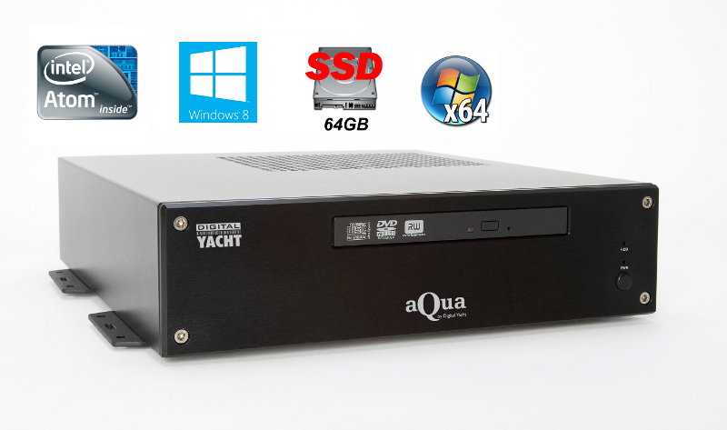
The Aqua range of PCs from Digital Yacht are designed to be permanently installed and can connect direct to the boats DC electrical system. They are capable of operation from 8-18V so can deal with a fluctuating battery supply. They also consume minimal power (typically around 1A at 12V DC) and are completely solid state with no moving parts. There’s no cooling fan to suck in moist air and the solid state hard drives offer exceptional reliability and speed. They also feature a dual NMEA input to integrate straight into your boats navigation system. Despite their impressive performance they are as affordable as a good quality laptop and can support multiple monitors.
Using the AIS transponder as the navigation feed…
If you’re contemplating a PC system then you’ll probably also look at having an AIS Transponder. Our AIT2000 features a USB output to connect direct to an Aqua PC and provides a feed of AIS and GPS information. It also incorporates a NMEA multiplexer so will take your boat’s instrument NMEA data and combine with the AIS data and output via USB. One connection to your PC with AIS, GPS and NMEA boat data!
Navigation Software for your PC…
One of the beauties of a PC based system is that you can constantly upgrade, change and evolve with the addition of new software. Of course, we’d like you to use our SmarterTrack navigation package which offers great value for money, amazing charting capabilities and one of the best AIS presentations available today. SmarterTrack uses Navionic’s charts and you’re now able to copy a Navionic’s chart (on SD or CF card – like the ones used on plotters such as Lowrance, Raymarine and Simrad) direct to you’re PCs hard drive – that means no duplicated charting costs! SmarterTrack supports weather overlays, instrument displays and can be supplied with a NMEA 2000 interface
Add wifi internet access with the WL510…
Internet access afloat really adds to boating. Not only can you keep abreast of news and email, but it’s a great source of entertainment, TV and media when in port. It can also be used to dowload the latest weather information. Free GRIB files are available to integrate with PC navigation programs to provide animated weather forecasts with wind, swell, pressure and temperature information. Whilst on board, you can access the internet through 3G/4G systems, WiFi and satellite. Digital Yacht make a range of high power wifi systems which offer easy and cheap data access with ranges of up to 5NM. WiFi is cheap, global and fast and for many coastal sailors, it’s ideal. Satellite provides a trans ocean solution but at a high price and substantial running cost. The WL510 will integrate with your on board PC system to provide internet access
Fitting it all together
So here’s how it all interconnects. In the cockpit or flybridge you can use any standard 5, 7, 10, 12 or 15″ multi function display/plotter, linking via NMEA direct to the Aqua PC system. 5″ plotters from Garmin, Raymarine and Lowrance offer incredible value for money, sunlight viewing capability and waterproof performance. Even a 5″ screen is ideal for use by the helsman and if you choose a Navionic’s based plotter, you can share the charting with SmarterTrack on the Aqua PC. Make sure your plotter choice accepts an AIS input too
In this system, we’ve added the WL510 for internet access, connected to our WiFi hub called iNavHub. This allows internet data as well as navigation NMEA data to be shared with mobile devices such as iPads/Phones.
We’ve also utilised our SPL2000 VHF-AIS antenna splitter to share the VHF antenna with the AIS transponder and provide an aerial feed to an on board stereo.
Its a powerful system that offers incredible value for money
2015 Update: Since writing this we’ve introduced our new Aqua Adapt range – more powerful, lower power and better value. Details Here

Comments 1
Comments are closed.